Where Is Konga Island?
PULAU KONGA

Geographic features & Photographs around Pulau Konga, in Indonesia (general), Indonesia populated place; a city, town, village, or other agglomeration of buildings where people live and work.
* Konga (8.5km) * Lewolaga (8.6km) * Nobo (8.6km) * Wairunu (13.5km) * Wolo (15.4km) * Lewotobi (17.1km) * Bama (27.3km) * Kedang (33.3km) * Lewotobi (35.3km) * Lewalen (36.8km) * Liko (38.1km) * Kloreamang (40.4km) * Balawelin (42.8km) * Kringa (44.5km) * Pamakayu (47km)
point; a tapering piece of land projecting into a body of water, less prominent than a cape.
* Tanjung Wailonga (19.1km) * Tanjung Lopez (21.4km) * Tanjung Prigi (25.5km) * Padang-wutun (27.3km) * Tanjung Tainedin (28km) * Wau-wutun (30.2km) * Tanjung Krungo (32.6km) * Tanjung Genderasi (33.8km) * Tanjung Woludama (38.7km) * Belolong-wutun (42.2km) * Kalika-wutun (47km) * Tanjung Gemok (52.6km)
mountain; an elevation standing high above the surrounding area with small summit area, steep slopes and local relief of 300m or more.
* Ili Muda (12.1km) * Ili Kawalelo (19.1km) * Ili Lewotobi-Lakilaki (23km) * Ili Gora (24.1km) * Ili Lewotobi-Perempuan (30.3km) * Gunung Wengor (31km)
Lewotobi Mountains, East Flores, NTT Province, Indonesia by Grahabudaya Indonesia
cape; a land area, more prominent than a point, projecting into the sea and marking a notable change in coastal direction.
* Tanjung Lopie (17km) * Tanjung Bela (30.8km) * Tanjung Lewurang (34.5km) * Lerang-wutun (43.1km)
Island at Konga Bay, East Flores, NTT, Indonesia by Grahabudayaindonesia
island; a tract of land, smaller than a continent, surrounded by water at high water.
* Pulau Konga (0km) * Nuha Witi (40.6km) * Nuha Lewurang (41.6km) * Nuha Beleng (53km)
trees with autumn leaves (Ritaebang Beach-Solor, Flores)by simon.nany stream; a body of running water moving to a lower level in a channel on land.
* Wai Konga (4.3km) * Wai Runu (13.5km) * Wai Liko (32.5km)
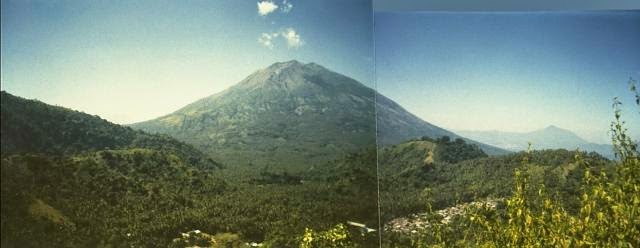
Mt. Ile Mandiri by Ng Sebastian
strait; a relatively narrow waterway, usually narrower and less extensive than a sound, connecting two larger bodies of water.
* Selat Flores (31km) * Selat Lewotobi (32.6km)
bay; a coastal indentation between two capes or headlands, larger than a cove but smaller than a gulf.
* Teluk Konga (4.3km) * Teluk Oka (36.2km)
SUNSET DI KONGA

(s); an extensive area of comparatively level to gently undulating land, lacking surface irregularities, and usually adjacent to a higher area.
* Liko Plain (38.1km)
WikipediaWikipedia entries close to Pulau Konga
* Lewotobi mountain volcano * Leroboleng mountain volcano * Ilimuda mountain volcano * Riang Kotang mountain volcano * Mount Egon mountain volcano * Iliboleng mountain volcano * Ililabalekan mountain volcano * Lewotolo mountain volcano * Iliwerung mountain volcano * Ndete Napu mountain volcano ............................ANA KONGA...................

Geographic features & Photographs around Pulau Konga, in Indonesia (general), Indonesia populated place; a city, town, village, or other agglomeration of buildings where people live and work.
* Konga (8.5km) * Lewolaga (8.6km) * Nobo (8.6km) * Wairunu (13.5km) * Wolo (15.4km) * Lewotobi (17.1km) * Bama (27.3km) * Kedang (33.3km) * Lewotobi (35.3km) * Lewalen (36.8km) * Liko (38.1km) * Kloreamang (40.4km) * Balawelin (42.8km) * Kringa (44.5km) * Pamakayu (47km)
point; a tapering piece of land projecting into a body of water, less prominent than a cape.
* Tanjung Wailonga (19.1km) * Tanjung Lopez (21.4km) * Tanjung Prigi (25.5km) * Padang-wutun (27.3km) * Tanjung Tainedin (28km) * Wau-wutun (30.2km) * Tanjung Krungo (32.6km) * Tanjung Genderasi (33.8km) * Tanjung Woludama (38.7km) * Belolong-wutun (42.2km) * Kalika-wutun (47km) * Tanjung Gemok (52.6km)
mountain; an elevation standing high above the surrounding area with small summit area, steep slopes and local relief of 300m or more.
* Ili Muda (12.1km) * Ili Kawalelo (19.1km) * Ili Lewotobi-Lakilaki (23km) * Ili Gora (24.1km) * Ili Lewotobi-Perempuan (30.3km) * Gunung Wengor (31km)
Lewotobi Mountains, East Flores, NTT Province, Indonesia by Grahabudaya Indonesia
cape; a land area, more prominent than a point, projecting into the sea and marking a notable change in coastal direction.
* Tanjung Lopie (17km) * Tanjung Bela (30.8km) * Tanjung Lewurang (34.5km) * Lerang-wutun (43.1km)
Island at Konga Bay, East Flores, NTT, Indonesia by Grahabudayaindonesia
island; a tract of land, smaller than a continent, surrounded by water at high water.
* Pulau Konga (0km) * Nuha Witi (40.6km) * Nuha Lewurang (41.6km) * Nuha Beleng (53km)
trees with autumn leaves (Ritaebang Beach-Solor, Flores)by simon.nany stream; a body of running water moving to a lower level in a channel on land.
* Wai Konga (4.3km) * Wai Runu (13.5km) * Wai Liko (32.5km)
Mt. Ile Mandiri by Ng Sebastian
strait; a relatively narrow waterway, usually narrower and less extensive than a sound, connecting two larger bodies of water.
* Selat Flores (31km) * Selat Lewotobi (32.6km)
bay; a coastal indentation between two capes or headlands, larger than a cove but smaller than a gulf.
* Teluk Konga (4.3km) * Teluk Oka (36.2km)
SUNSET DI KONGA

(s); an extensive area of comparatively level to gently undulating land, lacking surface irregularities, and usually adjacent to a higher area.
* Liko Plain (38.1km)
WikipediaWikipedia entries close to Pulau Konga
* Lewotobi mountain volcano * Leroboleng mountain volcano * Ilimuda mountain volcano * Riang Kotang mountain volcano * Mount Egon mountain volcano * Iliboleng mountain volcano * Ililabalekan mountain volcano * Lewotolo mountain volcano * Iliwerung mountain volcano * Ndete Napu mountain volcano ............................ANA KONGA...................
Komentar
Posting Komentar